 John Snider
The information on theses pages is provided by John Snider, who has been diligently working and recording all the gravesites in these small cemeteries. Thank you John! If you have any updates to any of the spreadsheets please email John [email protected].
Below are links to the spreadsheets containing names, birth & death dates etc. of individuals buried in the township of Rensselearville's small burial grounds. Click on each cemetery's link to view the spreadsheet.
If you are looking for a specific name but are unsure of the burial site, please use the spreadsheet with the compiled listings at the bottom of the page (coming soon). You can also search on Find a Grave.
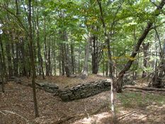
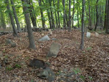 Photo by John G. Snider, Jr from findagrave.com Photo by John G. Snider, Jr from findagrave.com
Barrett Family Cemetery Medusa
Small family cemetery no longer in use or maintained. Directions - From the north: At the intersection of Routes 85 & 385 in the hamlet of Rensselaerville (NY), drive west on Rte. 385 for approx. .4 miles. Turn left onto Rte. 359. At .6 miles turn left again onto Rte. 360. Proceed 1.9 miles to cemetery. From the south: From the Rensselaerville Town Hall on Barger Rd., drive west on county Rte. 357. At .4 miles turn right on Rte. 360 and proceed 1.6 miles to cemetery. The site is approx. 100 yards back on the east side of the road at the corner of two stone walls and cannot be seen from the road. Please be aware that cemetery is on private property and permission should be obtained from land owner before visiting. Click here for the spreadsheet for individuals buried at Barrett Family Cemetery: Barrett Family Cemetery Spreadsheet |
Burhans Family Burial Ground
A small family cemetery no longer used or maintained. From the intersection of Routes 145 & 81 in the Town of Rensselaerville, drive west on Potter Hollow Rd. ( County Rte. 354) approx. 1.1 miles. At the "Y", bear right onto Scott Patent Rd. (County Rte. 362). At the 1.3 mile mark you will find the cemetery on your left next to the road. Due to lack of adequate parking, leave your car at the Potter Hollow Cemetery and walk the approx. 100' to the site. Click here for the spreadsheet for individuals buried at Burhans Family Burial Ground: Buhrans Family Burial Ground Spreadsheet
A small family cemetery no longer used or maintained. From the intersection of Routes 145 & 81 in the Town of Rensselaerville, drive west on Potter Hollow Rd. ( County Rte. 354) approx. 1.1 miles. At the "Y", bear right onto Scott Patent Rd. (County Rte. 362). At the 1.3 mile mark you will find the cemetery on your left next to the road. Due to lack of adequate parking, leave your car at the Potter Hollow Cemetery and walk the approx. 100' to the site. Click here for the spreadsheet for individuals buried at Burhans Family Burial Ground: Buhrans Family Burial Ground Spreadsheet
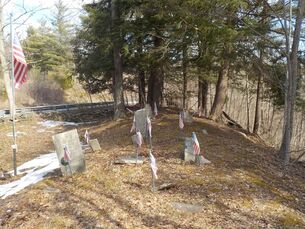
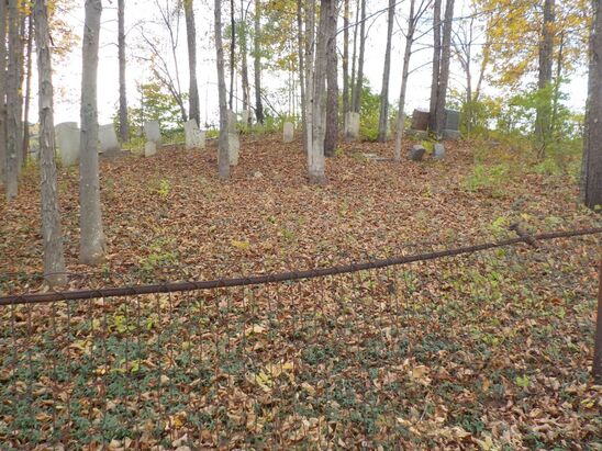
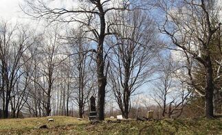 Photo by Scott Coyle from findagrave.com
Crystal Lake Cemetery Rensselaerville, New York, USA, Coordinates: 42.50780, -74.20440
Click here for the spreadsheet for individuals buried at Crystal Lake Cemetery: Crystal Lake Spreadsheet
Click here for the spreadsheet for individuals buried at Crystal Lake Cemetery: Crystal Lake Spreadsheet
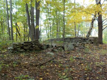
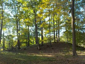
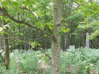 Photo by Carla Parrish from findagrave.com
Day Family Cemetery
A small family cemetery no longer used or maintained. It is located on the old Latany Day Farm, approximately 3/4 mile north of Hwy 353 on Olmo Lane. Click here for the spreadsheet for individuals buried at Day Family Cemetery on Olmo Lane: Day Family Spreadsheet
A small family cemetery no longer used or maintained. It is located on the old Latany Day Farm, approximately 3/4 mile north of Hwy 353 on Olmo Lane. Click here for the spreadsheet for individuals buried at Day Family Cemetery on Olmo Lane: Day Family Spreadsheet
Delamater Burying Ground
A small family cemetery no longer used or maintained. It is located on the old Latany Day Farm, approximately 3/4 mile north of Hwy 353 on Olmo Lane. Click here for the spreadsheet for individuals buried at Day Family Cemetery on Olmo Lane: Dealmater Burying Ground Spreadsheet
A small family cemetery no longer used or maintained. It is located on the old Latany Day Farm, approximately 3/4 mile north of Hwy 353 on Olmo Lane. Click here for the spreadsheet for individuals buried at Day Family Cemetery on Olmo Lane: Dealmater Burying Ground Spreadsheet
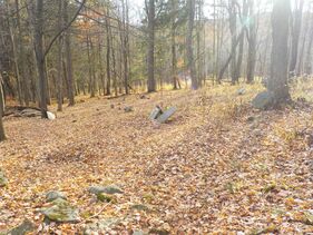
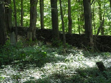 Photo by John Hulse from findagrave.com
Dumond Cemetery
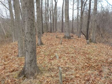
The cemetery is about 150 yards off Miller Road in Renssealerville, NY. It' not visible from the road (even in the fall after the leaves are off the trees). It took us three years to locate it. It's in very poor condition. Many of the stones are down or in the process of going down. In some cases they are under as much as 5 inches of debris and dirt. We have located and lifted about 10 stones to the surface and removed some fallen trees and branches). The inscriptions on some of the stones are impossible to read. There are a few head stones that appear to be completely blank (as if they were never carved) and many field stone markers (some with initials). Click here for the spreadsheet for individuals buried at Dumond Cemetery: Dumond cemetery Spreadsheet
The cemetery is about 150 yards off Miller Road in Renssealerville, NY. It' not visible from the road (even in the fall after the leaves are off the trees). It took us three years to locate it. It's in very poor condition. Many of the stones are down or in the process of going down. In some cases they are under as much as 5 inches of debris and dirt. We have located and lifted about 10 stones to the surface and removed some fallen trees and branches). The inscriptions on some of the stones are impossible to read. There are a few head stones that appear to be completely blank (as if they were never carved) and many field stone markers (some with initials). Click here for the spreadsheet for individuals buried at Dumond Cemetery: Dumond cemetery Spreadsheet
Fleming Ridge Cemetery
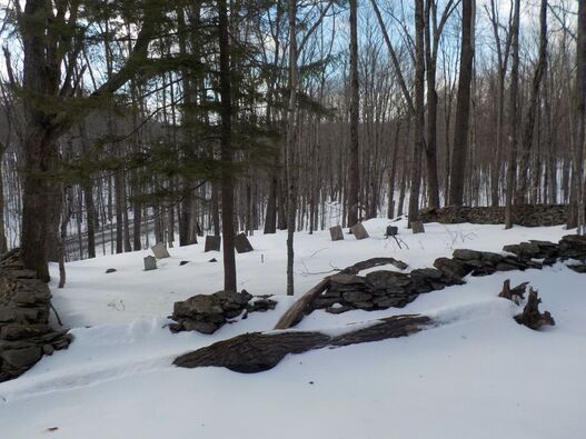
Small, multi-family burial site no longer in use or maintained. Twenty-one gravestones noted (possibly more) , only 12 with inscriptions. Directions: From the intersection of routes 85 & 351 in the hamlet of Rensselaerville, turn left on Rte. 351. Proceed 1.6 miles to Fleming Rd. Turn right and go approx .2 miles. Cemetery is on your right about 50 feet uphill surrounded by a stone wall. Please note that cemetery is on private property and permission from landowner must be obtained before visiting.
Click here for the spreadsheet for individuals buried at Fleming Ridge Cemetery on Fleming Road: Fleming Ridge Spreadsheet
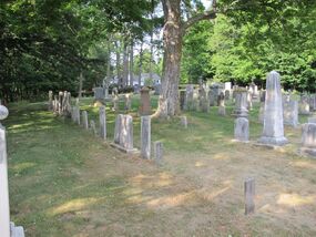
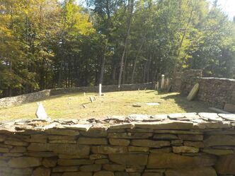 Photo by John G. Snider, Jr from findagrave.com
Hagadorn Burying Ground 329 County Route 357, Medusa
A small, multi-family burial ground located approx. 1/4 mile east of the Rensselaerville (NY) town hall. Recently cleaned up and restored, this site is on private property and permission of the landowner MUST be obtained before visiting. Click here for the spreadsheet for individuals buried at Hagadorn Burying Ground: Hagadorn Burying Ground Spreadsheet
A small, multi-family burial ground located approx. 1/4 mile east of the Rensselaerville (NY) town hall. Recently cleaned up and restored, this site is on private property and permission of the landowner MUST be obtained before visiting. Click here for the spreadsheet for individuals buried at Hagadorn Burying Ground: Hagadorn Burying Ground Spreadsheet
Kelsey Family Burial Ground
Small, single family burial site that has been abandoned and no longer maintained. Located on private property off county Rte. 352 and permission from landowner must be obtained before visiting. Click here for the spreadsheet for individuals buried at Kelsey Family Burial Ground: Kelsey Family Burial Ground Spreadsheet
Small, single family burial site that has been abandoned and no longer maintained. Located on private property off county Rte. 352 and permission from landowner must be obtained before visiting. Click here for the spreadsheet for individuals buried at Kelsey Family Burial Ground: Kelsey Family Burial Ground Spreadsheet
Lee Family Cemetery
A small family cemetery no longer in use or maintained. Located on private property, permission from landowner should be obtained before visiting. From the intersection of routes 85 & 353 in the hamlet of Rensselaerville, drive west on 353 for .3 miles. Turn left (south) onto Hale Rd. and proceed 2.2 miles to the site. Cemetery is on the east side of the road, on a small hillock, across approx. 200' of swampy ground which could make visitation difficult after a period of wet weather. At least 66 graves have been noted with more possible. Only two grave stones have been located with inscriptions on them, the rest being simple field stones. Click here for the spreadsheet for individuals buried at Lee Family Cemetery: Lee Family Cemetery Spreadsheet
A small family cemetery no longer in use or maintained. Located on private property, permission from landowner should be obtained before visiting. From the intersection of routes 85 & 353 in the hamlet of Rensselaerville, drive west on 353 for .3 miles. Turn left (south) onto Hale Rd. and proceed 2.2 miles to the site. Cemetery is on the east side of the road, on a small hillock, across approx. 200' of swampy ground which could make visitation difficult after a period of wet weather. At least 66 graves have been noted with more possible. Only two grave stones have been located with inscriptions on them, the rest being simple field stones. Click here for the spreadsheet for individuals buried at Lee Family Cemetery: Lee Family Cemetery Spreadsheet
Roney Road Cemetery
A small, multi-family cemetery that is no longer in use or maintained. Cemetery is located on private property and permission from land owner should be obtained before visiting. From the Rensselaerville town hall on Barger Rd., drive west on County Rte. 352 for 2.2 miles where you will turn right onto Pearson Rd. At .3 miles turn right again onto Roney Rd. Proceed 1.9 miles to where road makes an abrupt 90 deg. turn. Cemetery is located approx. 100 yards up dirt road on left. Look for low stone wall in among trees on your right. Click here for the spreadsheet for individuals buried at Roney Road Cemetery: Roney Road Cemetery Spreadsheet
A small, multi-family cemetery that is no longer in use or maintained. Cemetery is located on private property and permission from land owner should be obtained before visiting. From the Rensselaerville town hall on Barger Rd., drive west on County Rte. 352 for 2.2 miles where you will turn right onto Pearson Rd. At .3 miles turn right again onto Roney Rd. Proceed 1.9 miles to where road makes an abrupt 90 deg. turn. Cemetery is located approx. 100 yards up dirt road on left. Look for low stone wall in among trees on your right. Click here for the spreadsheet for individuals buried at Roney Road Cemetery: Roney Road Cemetery Spreadsheet
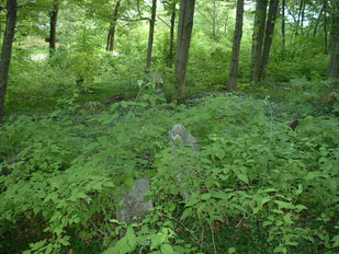 Photo by Norm Hopkins from findagrave.com
Scutt Family Cemetery
A small family cemetery, no longer in use or maintained, located on Scutt Road in Preston Hollow, NY. GPS Coordinates: 42.48308, -74.20909. Click here for the spreadsheet for individuals buried at Scutt Family Cemetery: Scutt Family Cemetery Spreadsheet
A small family cemetery, no longer in use or maintained, located on Scutt Road in Preston Hollow, NY. GPS Coordinates: 42.48308, -74.20909. Click here for the spreadsheet for individuals buried at Scutt Family Cemetery: Scutt Family Cemetery Spreadsheet
Smith Family Cemetery
A small family cemetery presently located on the grounds of the E.N. Huyck Preserve. Please follow Preserve rules and regulations when visiting. From the intersection of routes 85 & 353 in the hamlet of Rensselaerville, drive west on route 353 for 1.2 miles. Turn right onto Bryan Rd. and proceed .4 miles. Cemetery is on the right approx. 100 ft. uphill in woods. Click here for the spreadsheet for individuals buried at Smith Family Cemetery: Smith Family Cemetery Spreadsheet
A small family cemetery presently located on the grounds of the E.N. Huyck Preserve. Please follow Preserve rules and regulations when visiting. From the intersection of routes 85 & 353 in the hamlet of Rensselaerville, drive west on route 353 for 1.2 miles. Turn right onto Bryan Rd. and proceed .4 miles. Cemetery is on the right approx. 100 ft. uphill in woods. Click here for the spreadsheet for individuals buried at Smith Family Cemetery: Smith Family Cemetery Spreadsheet
Snyder Cemetery
Cemetery no longer in use or maintained. From the intersection of County Route 352 and Willsey Rd, drive north for .8 miles. Cemetery is on the left side approx. 200 feet from the road. At least 53 graves noted, possibly more, many marked with simple field stones. Click here for the spreadsheet for individuals buried at Snyder Cemetery: Snyder Cemetery Spreadsheet
Cemetery no longer in use or maintained. From the intersection of County Route 352 and Willsey Rd, drive north for .8 miles. Cemetery is on the left side approx. 200 feet from the road. At least 53 graves noted, possibly more, many marked with simple field stones. Click here for the spreadsheet for individuals buried at Snyder Cemetery: Snyder Cemetery Spreadsheet
Tanner Family Plot
There is a known family plot near Lewisdale Farms that is related to the original 19th century inhabitants, John and Elizabeth (Wightman) Tanner. The exact location of the cemetery on this property has not been confirmed, but the transcriptions of several of the headstones found on the property were shared by the owners. Click here for the spreadsheet for individuals buried at Tanner Family Plot: Tanner Family Plot Spreadsheet
There is a known family plot near Lewisdale Farms that is related to the original 19th century inhabitants, John and Elizabeth (Wightman) Tanner. The exact location of the cemetery on this property has not been confirmed, but the transcriptions of several of the headstones found on the property were shared by the owners. Click here for the spreadsheet for individuals buried at Tanner Family Plot: Tanner Family Plot Spreadsheet
Trinity Church Cemetery Trinity Lane, Rensselaerville, New York 12147
Coordinates: 42.51596, -74.13281
Cemetery is located next to the church on Trinity Lane which is off Albany Hill Road, also known as Co. Rd. 361. Click here for the spreadsheet for individuals buried at Trinity Church Cemetery: Trinity Church Cemetery Spreadsheet
Coordinates: 42.51596, -74.13281
Cemetery is located next to the church on Trinity Lane which is off Albany Hill Road, also known as Co. Rd. 361. Click here for the spreadsheet for individuals buried at Trinity Church Cemetery: Trinity Church Cemetery Spreadsheet
Wheeler Watson Cemetery
Park at the Eldridge Research Center, The Huyck Preserve, 284 Pond Hill Rd, Rensselaerville, NY 12147. Walk east along Pond Hill Road for 800 feet. Intercept the Wheeler-Watson Trail and walk north 400 feet. Click here for the spreadsheet for individuals buried at Wheeler Watson Cemetery: Wheeler Watson Cemetery Spreadsheet
Park at the Eldridge Research Center, The Huyck Preserve, 284 Pond Hill Rd, Rensselaerville, NY 12147. Walk east along Pond Hill Road for 800 feet. Intercept the Wheeler-Watson Trail and walk north 400 feet. Click here for the spreadsheet for individuals buried at Wheeler Watson Cemetery: Wheeler Watson Cemetery Spreadsheet